

Let's take a stroll around Fuchu and Kokubunji!
Fuchu city & Kokubunji city Course
Fuchu and Kokubunji surrounded by greenery in Musashino Plains to this day, were developed as one of the centers in the ancient country, where Kokufu (provincial capital) and Kokubunji (provincial temple) were constructed.
This walking course is selected to see the ancient history of Musashi Kokufu-ato and Musashi Kokubunji-ato, and the nature in Musashino Plains, such as Masugata no Ike.
Let's take a stroll around Fuchu and Kokubunji, imaging the ancient Tokyo!
Finding the ancient history
The ancient nations of the Asuka and the Nara periods divided the whole country into Goki-Shichido (the five regions and the seven districts) and established over sixty provinces. Musashi Province was a "giant province" consisted of the current Saitama Prefecture, Tokyo and a part of Kanagawa Prefecture. It had divided to 21 county units such as Tama, Toshima, and Adachi, and its ancient provincial center was established in the current Fuchu city.
Musashi Province belonged to Tosando Road (East Mountain Road District). And Tosando Musashi-Michi Road (the ancient public road) which branched off near the Nitta station of Kozuke Province (current Gunma Prefecture) had been connected to Fuchu, the ancient provincial capital.
Approximately 2km north of the capital, Provincial Monastery and Provincial Nunnery were constructed respectively in the east and the west side of the ancient public road (Tosando Musashi-Michi Road). Provincial Monastery and Nunnery were the official Buddhist temples which had been constructed by the imperial edict of the Emperor Shomu in 741, and the large temples were completed with the mobilization of the people of Musashi Province.
So, there are many ancient remains, as the area used to be a center of politics in the Nara and the Heian period. Also, many remains of the Jomon and the Kofun period are found, because this area has considerable amount of spring water coming out from Fuchu and Kokubunji Cliffs.
Besides, on the west of Fuchu Provincial center, influential mounded tombs were constructed, among these is "Musashi Fuchu Kumano Jinja Kofun", which is the largest one with dome-shaped knoll on a square in Japan.
Walking Course Highlights / Fuchu city
Walking Course Highlights / Kokubunji city
Musashi Kokubunji Temple Remains Museum
Route Map

Brochure (PDF)
Fuchu city & Kokubunji city Course
Let's Stroll around Fuchu!
Kokucho (or Kokuga) had a local governmental headquarters equivalent to the current Metropolitan office or prefectural office, working Kokushi (provincial governors) were sent to the appointed province. Kokufu means cities developed around the Kokuga and related organization.
The name of Fuchu, which means "the center of Kokufu", comes from the place of the Provincial center.
According to the historical examples from other parts in Japan, it is thought that the Provincial Government Office was established at the beginning of the 8th century when the national capital was transferred to Heijo, while the establishment of the Provincial center is thought to have been dated back around the end of the 7th century. The Provincial center had been reduced their political power under the Ritsuryo codes by the latter half of the 10th century, but the Fuchu area had carried on with the role of the political center throughout from the Ancient period to the Medieval period.
In Medieval period, Musashi Sosha Shrine (also called Rokusho-gu) which was predecessor of Okunitama Jinja Shrine (named after the Meiji period) was constructed in the Provincial Government Office (Kokuga) area. At that time, Fuchu area flourished as a town of where Rokusho-gu Shrine, but it was also important as transportation hub and strategic site which you can overlook the Tama-gawa River. Bubaigawara which is located below Fuchu Cliffs where battles were took place in 1333, and Koanji Temple which is located on the cliffs, troops such as the Kamakura shogunate's often camped.
In the Pre-modern period, in the year when Tokugawa Ieyasu entered Edo, Fuchu Goten (Fuchu Palace) was built as an accommodation for Toyotomi Hideyoshi and Ieyasu also made a respectful guardian for Rokusho-gu. Fuchu area prospered as a post-station town on the Koshokaid. Road and its townscape has been flourished up to now.

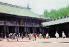
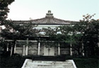
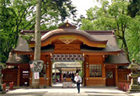
Taking a Walk in Okunitama Jinja Shrine

Okunitama Jinja Shrine

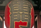
Kurayami matsuri Festival
In the chronicle of Okunitama Jinja Shrine, it is described in its own records as it was erected on May 5, the 41st year of the Keiko Emperor(111), and each generation of territorial governors had served for it. When Musashi Kokufu (provincial city) was set in this area at the early Nara period, Okunitama Jinja Shrine was appointed to be a Soja (shrine enshrining several god) has collected 6 gods of local shrines and enshrined them together, which were the shrines of Ono Jinja Shrine (Ichinomiya, Tama City), Ninomiya Jinja Shrine (Ninomiya, Akiruno City), Hikawa Jinja Shrine(Takahana-cho, Omiya City, Saitama City), Chichibu Jinja Shrine (Banba-cho, Chichibu City, Saitama Prefecture), Kanasana Jinja Shrine(Ninomiya, Kanagawa-cho, Saitama Prefecture) and Sugiyama Jinja Shrine(Hassaku-cho, Midori Ward, Yokohama City). It is noted in the history book "Azuma Kagami" that the Rokusho-gu Shrine was counted as one of the 10 shrines in Kanto region, where Hojo Masako, who was the wife of Minamoto-no Yoritomo, a Kamakura shogun prayed for safe childbirth. Thus, it has earned faith from the people in Musashi territory since old times. In Edo period, the Tokugawa government contributed an area of 500 koku to the shrine. Buildings of the shrine were reformed or built several times. It was renamed to Okunitama in 1871.
Kurayami-matsuri Festival is Reitaisai (regular rites and festival) held on for a golden week in May, fests the rituals and the entertainments. The festival reaches its climax, when 8 portable shrines proceed lead by 6 huge Japanese drums in the evening of May 5th. It is a worthy festival that retains firm the tradition from the Middle Ages. The festival is designated as an intangible property of Tokyo.
1
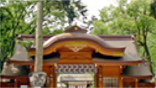
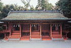
Okunitama Jinja Honden
(Main Hall of Okunitama Jinja Shrine)

Main Hall of Okunitama Jinja Shrine
Okunitama no Okami and others are enshrined in the main hall at the center, and three shrines each are installed together in the east and west halls. In the past, each shrine seems to have had own hall, as the old map in 1606 shows.
Almost all the buildings of Okunitama Jinja Shrine were destroyed by fire in 1646. The present main hall was completed in 1667 on the order of the forth shogun Tokugawa Ietsuna to reconstruct them.
Three buildings built in "sangensha-nagarezukuri" (which means to have frontage which is divided into three spans by pillars, and roofs which are warped gently) style are arranged side by side with no gap. Such peculiar and rare style is called "kyukensha-nagarezukuri" which means to have frontage with nine spans and warped roofs. Three shrines share one by one in a building, in the style which is called "aidenzukuri". The total length of ridge is about 14 meters and the height reaches about 9 meters. The main building surrounded by hedge, is vermillion-lacquered and looks attractive with the white gravel filled inside of the hedge. The roof was covered by sliced bark of Japanese cypress before, but changed into the copperplate at the end of the Edo period.
Ridgepole plate and praying labels which are dated in 1667, still exist and you can see the name of the 4th shogun Ietsuna written on praying label.
The buildings are precious also as examples of construction ordered by shogun.
Opening Information of the Okunitama Jinja Honden
- Opening Days:
- All year (Allowed to look at only the exterior)
- Opening Times:
- All day (Allowed to look at only the exterior)
- Fee:
- Free (Allowed to look at only the exterior)
Fuchu city & Kokubunji city Course
2 Mokuzo Komainu (Wooden guardian dogs)

Wooden guardian dogs
A pair of Komainu (guardian dogs), one opens its mouth wide (a-gyo), the other closes tight (un-gyo), is made of Japanese cypress wood. A-gyo heights 70.3 cm, un-gyo 72.1 cm. Both are assembled from abandoned wood pieces, with Crystal eyes, and have the traces of decoration by gold leaf on lacquer coating all over their body.
A-gyo seems as if it is now going to bark, un-gyo stands ready with giving a sharp glint in its eyes. They are muscular and have well-balanced body and front legs. The expression of sturdiness and reality has the strength which moves viewers overwhelmingly.
The wooden plates enclosed in the body of a-gyo is inscribed by carbon ink, you can see that Hirauchi Masanobu who was the chief of carpenters working for the Edo shogunate, made them in 1619. Masanobu is known as that during the Keicho era(1596-1615). He directed the construction of Okunitama Jinja Shrine. Though, the sculptures are said to be attributed by Unkei who lived in the beginning of the Kamakura period, as well, due to the resemblance in style.
These guardian dogs were originally set by the pillars of Middle Gate, facing each other. They are good representatives of guardian dogs of Musashi Sosha Shrine, having courageous spirit. Nowdays we can see inside the Homotsuden.
Opening Information of the Mokuzo Komainu
- Opening Days:
- Saturdays, Sundays, holidays, festival days of the shrine
- Opening Times:
- 10:00~16:00
- Fee:
- General:200yen Students:100yen
Fuchu city & Kokubunji city Course
3
Musashi Kokufu Ato
(Remains of Musashi Provincial center)

Remains of Musashi Provincial Center
The site of Kokufu (Provincial center) is located on the center of the Kokuga (Provincial Government Office). Portion of the building was restored on the site to be shown to the opened to the public.
Since there are only few documents about the ancient provincial center, archaeological technique is indispensable for the investigation. Fuchu City has continuously excavated investigation around an urban area since 1975. One of the archaeological study, Provincial Government Office had been identified.
In the area of 300m long north and south, 200m long east and west, was surrounded by huge ditches for partitioning, some characteristic ruins and artifacts were excavated such as the remains of large scale buildings in a straight line and a lot of roof tiles.
Also the landscape of the whole Provincial center has been described by the archaeological research. Near the Provincial center, where 2.2km east and west, 1.8km north and south, clustered dug-standing pillar buildings were excavated. The remains of ancient road running north-south straight and buildings along the road show the existence of city planning in the Nara period.
In addition, a lot if ruins were also founded such as Kokushi (Provincial Governor)'s building who was appointed from Nara, a ruin presumed as ancient Governmental Office, and dwelling sites with well or blacksmiths' workshop.
Also stationaries such as tin or knife used for scraping wooden Tablet which used at government office, potteries and life facilities such as ironware and potteries weitten by name of facilities and personal names have been excavated. So life style of the people who used to live there could be found.
Opening Information of the Musashi Kokufu Ato
- Opening Days:
- All year(Except on the year's end and beginning)
- Opening Times:
- 9:00~17:00
- Fee:
- Free
Fuchu city & Kokubunji city Course
4
Babadaimon no Keyaki Namiki
(two rows of Zelkova trees along the avenue)

Babadaimon no Keyaki Namiki
These zelkova trees are planted along the avenue leading to north from Okunitama Jinja Shrine for over 600 meters. They are the second history natural monument which was designated in 1924. At the time of its designation, more than 60 of huge zelkova trees were planted regularly with Inushide (Carpinus tschonoskii), Konara (Quercus serrata), and Japanese cedars, giving magnificent landscape.
These trees were said to have begun contributing 2 blocks of riding grounds and trees to Okunitama Jinja Shrine by Ieyasu, the first Tokugawa shogun. By the end of the Edo period, horse markets had been held here.
Walking along the avenue forward north from the shrine, you can see the statue of Minamoto-no Yoshiie at the right side of the sidewalk. This statue was built in 1992, who is said to be the first man of planting the trees here for the gratitude of his victory in Zenkunen-no-eki Fight in the Heian period.
Walking along further north, you reach to the Fuchu railway station of Keio Line. Although during the Edo period, around Keyaki Namiki there were less people than the area of Koshukaido Road which had posting station. But after the Meiji period, this avenue has become town central of Koshukaido Road and railway. Therefore this avenue has become difficult to maintain Keyaki Namiki according to over traffic, city town, and old tree plants. Local citizens have been taking care of conservation and environment service for nearly over 60 years.
Opening Information of the Babadaimon no Keyaki Namiki
- Opening Days:
- All year
- Opening Times:
- All day
- Fee:
- Free
Fuchu city & Kokubunji city Course
5 Fuchu Kosatsuba

Fuchu Kosatsuba
Fuchu Kosatsuba is located at the corner of the crossing with the former Koshukaido Road and Fuchukaido Road, where the center of the post town in Fuchu was once there. Kosatsuba is a place to put up a notice board on which notifications and bans from the Edo shogunate were written by carbon ink. Kosatsuba was built in the center of villages or post town on the roads, carried out its important roles for demonstrating dignity of the shogunate.
Since Fuchu Kosatsuba was located with heavy traffic in the post town, the large number of Kosatsu were put up here. A document record is remaining putting up ten of Kosatsu in 1838. Their contents were about the daily life, that is, to live peacefully with family, or about the bans form the shogunate, that is, on belief in Christianity or on use of guns and so on.
Previously it had been built facing the road. After the traffic accident in 1965, it was rebuilt diagonally to the crossing. Nowdays there are only a few remaining, therefore Fuchu Kosatsuba is very much valuable.
Opening Information of the Fuchu Kosatsuba
- Opening Days:
- All year
- Opening Times:
- All day
- Fee:
- Free
Fuchu city & Kokubunji city Course
Let's Take a Stroll around Kokubunji!

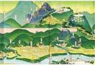
Image of Musashi Kokubun-soji;
Photo credit: Musashi Kokubunji Temple Remains Museum
Musashi Kokubunji Temple was founded about 2km to the north of Kokufu in Fuchu City, which consisted of "monastery" and "nunnery" built on the east and west sides of "Tosando Musashi-michi Road". Kokubunji Temples were constructed all over the country by the edict of Emperor Shomu "Kokubunji Konryu no Mikotonori" issued in 741. Musashi Kokubunji Temple is estimated to be founded in Tenpyo-hoji era (757-65 AD), according to the archaeological finds and "lacquer document".
Kokubunji Temples were constructed in 60-some provinces throughout the country, but some of them are unknown as to their whereabouts. In Kokubunji City, Both "monastery" and "nunnery" are identified and preserved in the same area. Musashi Kokubunji Temple Site is a quite precious among the other Kokubunji Temples. This temple would have been very magnificent, as its scale was huge as Kokubunji Temple and the seven-storied pagoda was built there.
According to the chronicle "Shoku Nihon Koki", the seven-storied pagoda was burn down by lightening in 835, and its rebuilding was applied and permitted after ten years from the destruction. In the early 10th century, the temple was gradually declined, as the divisional ditches of the precincts had been buried. In 1333, the temple was wholly destroyed by fire at the battle of Bubaigawara between Nitta Yoshisada and Kamakura shogunate. In 1335, Yakushi-do Hall was reconstructed by Nitta Yoshisada. The current Kokubunji Temple descends from the ancient Musashi Kokubunji Temple.
Kokubunji Temples were decided to be founded on a pure place by the imperial edict. Musashi Kokubunji is a fine place, as there are a lot of rich springs and greens from Kokubunji Terrace, which is important. By the way, the terrace as in Kokubunji area is called "Hake" in Japanese archaic word. The novel "Musashino Fujin" written by Ooka Shohei is the story which this place as a stage.


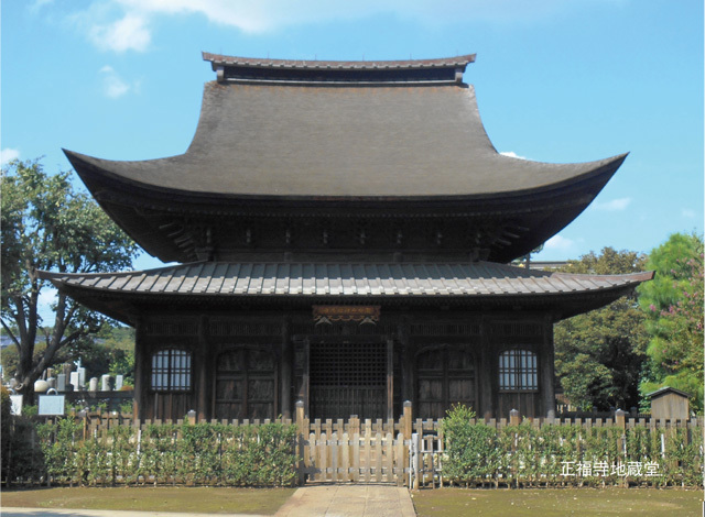
1 Musashi Kokubunji-ato, Tsuketari Tosan-do Musashi-michi-ato (Musashi Kokubunji Temple Site, Appendix: Tosan-do Musashi-michi Road Site)

Propery completed lecture hall;
Photo credit: Musashi Kokubunji Temple Remains Museum

Musashi Kokubun-niji-ato Site;
Photo credit: Musashi Kokubunji Temple Remains Museum
Musashi Province was connected far away to the capital of Nara by Tosan-do Road and its branch. Tosan-do Road ran through Omi, Mino, Shinano and Kozuke Provinces to Dewa and Mutsu Districts. To go to the capital of Musashi Province, people turned at the Nitta Station, Kozuke Province (current Ota City, Gunma Prefecture) and went south from there. On the way, Musashi Kokubunji Temple (monastery and nunnery) was built about 2km before the capital.
There is no precise record about the founding date of the temple, but it is estimated to be completed in the Tenpyo-hoji era (757-65 AD), according to the date of the roof-tiles with letters, the lacquered document and the style of roof-tiles. The development of the temple is divided into three stages; the founding stage (the first stage), the repair and expansion stage of the main buildings accompanied with the burning down and reconstruction of the seven-storied pagoda in the 9th century (the second stage) and the declined stage with the collapse of the governmental system from the 10th century to the 11th century (the third stage).
The monastery was built on the east of the national road "Tosan-do Musashi-michi Road". It consists of triple areas: center area, main buildings area and the other buildings area. The layout of the temple is Todai-ji Temple style; the south gate, the middle gate, the golden hall and the lecture hall are arranged in a line and the pagoda is built outside the corridor.
The nunnery was built on the west of the national road "Tosan-do Musashi-michi Road". It consists of double areas: center area and main buildings area. No pagoda was constructed. In the center area, the golden hall, the middle gate and the residence for nuns are identified in the excavations.
At present, Kokubunji City carries the project for restoring and maintaining Musashi Kokubunji-ato Site under the results of the excavations. In the monastery area, the lecture hall has been restored from 2013 for 2 years. Its stylobate is restored, and the trace of the building is indicated on the surface. The stylobate is a platform for the base of buildings. The edge of the stylobate of the lecture hall is revealed to be decorated with roof-tiles. In its restoration, the ancient roof-tiles are re-created and filled there. The genuine ancient roof-tiles from the excavations and the replicas that citizens made are partly used.
When going north from Kokubunji-ato site toward JR Nishikokubunji Station crossing to north for Municipal 4th Primary School on the right, and crossing the street, you will find an extremely wide sidewalk, which is about three times as wide as a roadway. This is the restored display of the national road "Tosan-do Musashi-michi Road", which was 12m in width and made straight. Let's walk on it, feeling the large size of the ancient road!
Opening Information of the Musashi Kokubunji Ato, Tsuketari Tosando Musashimichi Ato
- Opening Days:
- All year
- Opening Times:
- All day
- Fee:
- Free
Fuchu city & Kokubunji city Course
2
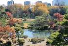
Masugata no Ike Yusui-gun
(Masugata no Ike Yusui-gun Springs)

Masugata no Ike Yusuigun Springs
There are many points where springs flows under Kokubunji Terrace. "Masugata no Ike Pond" and "Masugata no Ike Yusui-gun Springs" belongs to them. Many zelkova trees and Japanese cedars are found around there. The view of copse in Kokubunji Terrace is well preserved from the past. The pond was used as drinking water in the past.
The name "Masugata no Ike" is derived from one legend handed down to this area. In 848, there was a lady named "Tamatsukuri Komachi", who suffered from a skin disease. She visited Kokubunji Temple to pray for her cure from the disease. On the 21st day after she started to pray, a child appeared, took her to the pond and left a message to purify her body in it. When following his message, she was cured and got her original beauty back. People started to call the pond "Masugata no Ike", after the pond reflected her "Masugata (original figure)".
At present, there is a small shrine that enshrines Benzai-ten around the pond. A lot of Ema (votive horse tablet) that snakes are painted are offered in the shrine, and some visit to pray for their cure from disease or easy delivery of baby. The principle image of the shrine is unveiled once in twelve years, and it was done in 2013.
The surroundings of Masugata no Ike Pond are environed by well-kept copse, and the beautiful landscapes are well preserved, though in the urban area. They are selected as "100 Exquisite and Well-Conserved Waters" by Ministry of the Environment and "57 Exquisite spring waters in Tokyo" by Tokyo Metropolitan Government.
Opening Information of the Masugata no Ike Yusuigun
- Opening Days:
- All year
- Opening Times:
- All day
- Fee:
- Free
 (Pay)
(Pay)
Fuchu city & Kokubunji city Course
Let's Visit Musashi Kokubunji Temple Remains Museum
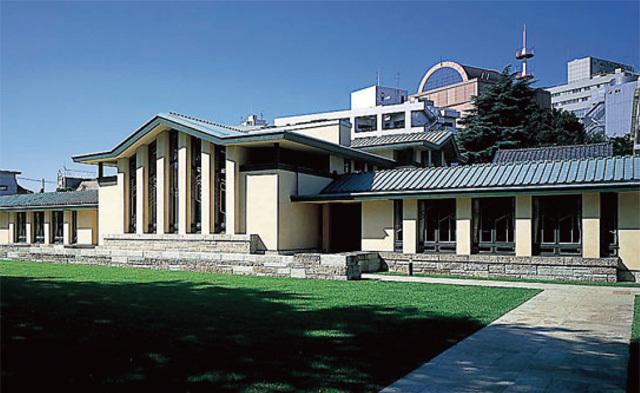
Musashi Kokubunji Temple Remains Museum opened in October, 2009. It is located in the monastery area of Musashi Kokubunji-ato Site, on the east of current Kokubunji Temple, in "Otaka no Michi Yusui-en Park". Here is the residence site of Honda Family who served a headman of Kokubunji Village, and Nagaya-mon Gate and a store house are preserved. In the museum, the archaeological finds from Musashi Kokubunji-ato Site are mainly exhibited based on the concept "to see", "to learn" and "to visit". There is the source of spring water in the museum grounds, too. You can feel a calm atmosphere in the museum.
3
Musashi Kokubunji-ato Shutsudo no Ryokuyu Kamon Zara
(Green Glazed Plate with Flower Design from Musashi Kokubunji-ato Site)

A lot of pit dwellings were built around Musashi Kokubunji Temple, where people concerned to with the construction and administration of the temple lived. This plate was discovered at one of the remains of pit dwelling, excavated in the Municipal 4th Junior High School located between the monastery and the nunnery. This ceramic plate has a diameter of 15.7 cm and a height of 2.65 cm, wholly coated with an olive green glaze. When looking carefully at the plate, people find that a flower pattern is designed. It is estimated to be produced around Seto City, Aichi Prefecture in the middle of 10th century AD.
The Seed-Syllable of Dainichi Buddha "Vam" is carved at the center of the plated in Sanskrit, and many stamens and eight plates of lotus flower surround it with line engraving. These characteristics shows that this plate would be used as a ritual implement in Buddhist ceremonies.
Musashi Kokubunji Temple Remains Museum
- Address:
- 1-13-10, Nishimotomachi, Kokubunji-shi, Tokyo 185-0023
- TEL :
- 042-323-4103
- FAX :
- 042-300-0091
- Opening Times:
- 9:00-17:00 (Enter by 16:45)
- Closed Days :
- Monday (if a holiday falls on them, Tuesdays), The year's end and beginning, Temporary closing days
- Fee :
- 100yen (free for under junior high school students)
You can buy a ticket at Rest Station of Historic Ruins.
No parking
There's a cafe ("Ota-cafe") at Rest Station of Historic Ruins.
Fuchu city & Kokubunji city Course
4
Karakusa Shiju-mon Do-buta
(Bronze Lid with Arabesque and Four Devine Beasts Design)

This bronze lid was excavated from the pit dwelling around Musashi Kokubunji Temple, which suggests to have been a blacksmith’s workshop. This pit dwelling seems to have been burned down; the bronze lid is generally bent and partly melted by heat too.
In processing of the preservation, a pattern by line engraving was revealed on the exterior surface of the lid. The bead pattern and four-petals pattern were carved inside the crown, and the arabesque design, beast design and stippling were done outside of the crown. This lid is supposed to be for a bronze bowl or a nest of bowls.
This design is in common with that of Sahari-no-futa No.2 owned by Shoso-in Treasure Repository, and it is indicated that the lid may have been made in the Korean peninsula. However, it is unclear how it was brought here.
Musashi Kokubunji Temple Remains Museum
- Address:
- 1-13-10, Nishimotomachi, Kokubunji-shi, Tokyo 185-0023
- TEL :
- 042-323-4103
- FAX :
- 042-300-0091
- Opening Times:
- 9:00-17:00 (Enter by 16:45)
- Closed Days :
- Monday (if a holiday falls on them, Tuesdays), The year's end and beginning, Temporary closing days
- Fee :
- 100yen (free for under junior high school students)
You can buy a ticket at Rest Station of Historic Ruins.
No parking
There's a cafe ("Ota-cafe") at Rest Station of Historic Ruins.
Fuchu city & Kokubunji city Course
5
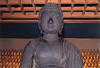
Dozo Kanzeon Bosatsu Ryu-zo
(Bronze Standing Statue of Kanzeon Bosatsu)

This statue was excavated from the remain of Tosan-do Musashi-michi Road, which ran north to south between the monastery and the nunnery, in the research for verifying the precinct of Musashi Kokubun-niji Temple in 1982.
The statue has a height of 28.4 cm, wearing a three-sided low crown decorated with the small statues of Amida Nyorai and showing a smile on its lips. The characteristics of its body are the broad shoulders and the lower belly sticking out. The major part of the pedestal was lost.
It is estimated to be made in the late Hakuho Age (from the late 7th century AD to the early 8th century AD), because such style is similar to the statue of Yumedono Kannon owned by Horyu-ji Temple in Nara.
This bronze statue is a precious cultural property, because it belongs to the old period as a bronze statue in the Hakuho Age known in the Kanto region, and there is a high possibility that the Japanese copper were used to make it as a raw material, according to the copper component analysis. It may suffer from a fire after buried, because of the traces of burning. Also, it lost the pedestal, the left arm from elbow, the right fingers and a part of robe.
Musashi Kokubunji Temple Remains Museum
- Address:
- 1-13-10, Nishimotomachi, Kokubunji-shi, Tokyo 185-0023
- TEL :
- 042-323-4103
- FAX :
- 042-300-0091
- Opening Times:
- 9:00-17:00 (Enter by 16:45)
- Closed Days :
- Monday (if a holiday falls on them, Tuesdays), The year's end and beginning, Temporary closing days
- Fee :
- 100yen (free for under junior high school students)
You can buy a ticket at Rest Station of Historic Ruins.
No parking
There's a cafe ("Ota-cafe") at Rest Station of Historic Ruins.
Tokyo Cultural Heritage Map
Would you like to go around cultural heritages? In Tokyo, there are various cultural heritages. This map helps you go around cultural heritages with efficiency during limited time in your trip. Japanese traditional temples and shrines, the cultural heritages concerned to most famous events and person in Japan and a lot of nature. This map introduces all of them widely! You must watch them and know the history and the culture of Tokyo!


SNS